

Harlingen is an unincorporated area within the Belle Mead section of Montgomery Township, New Jersey. It is adjacent to the historical areas of Dutchtown, New Jersey and Bridgepoint, New Jersey. Harlingen Road and U.S. Route 206, are in Harlingen. The Harlingen Dutch Reformed Church on Route 206 is extant and had an associated cemetery. The town was a stop on the short-lived Mercer and Somerset Railway.
| Harlingen | |
|---|---|
| — Unincorporated area — | |
 Harlingen | |
| Coordinates: 40°26′45″N 74°39′53″W / 40.44583°N 74.66472°WCoordinates: | |
| Country | United States |
| State | New Jersey |
| County | Somerset |
| Township | Montgomery |
| Time zone | Eastern (EST) (UTC-5) |
| • Summer (DST) | EDT (UTC-4) |
| ZIP codes | |
| FIPS code | |
| GNIS feature ID | |

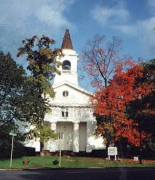
Harlingen Dutch Reformed Church
The Harlingen Dutch Reformed Church is in the Belle Mead, New Jersey section of Montgomery Township. The congregation was organized in 1727, and the minister was one of the major antagonists in the dispute between the traditionalists and the American party that contested governance of the Dutch Reformed Church. The church is still active.
  |
Geen opmerkingen:
Een reactie posten